

Back to Part 3: Traffic Flow and Junctions

What needs to change, then?
Many of the things that need to change are in principle not necessarily that difficult or even different to what we’re currently doing. I was reading a popular textbook on traffic engineering recently, and saw a stepped diagram relating carriageway width to vehicle capacity. It looked like this, with carriageway width along the bottom, and saturation flow (passenger car units) along the left. You can see the capacity shoot up at the point where you go from one lane to two, for example.
I thought, why don’t we see, in these textbooks, this kind of graph in relation to planning for cycling? We know high levels of motor traffic to be an important factor in deterring most people from cycling. Why aren’t we parameterising this, and putting it into models that tell us what kinds of journeys are currently cycle-able for most people, and what we need to do in order to make the journeys people could make by bike (in terms of distance) cycle-able by the majority? In the graph below I’ve made up the numbers, but it wouldn’t be that hard to do some research to establish reasonable parameters, and to monitor changes and differences between areas.
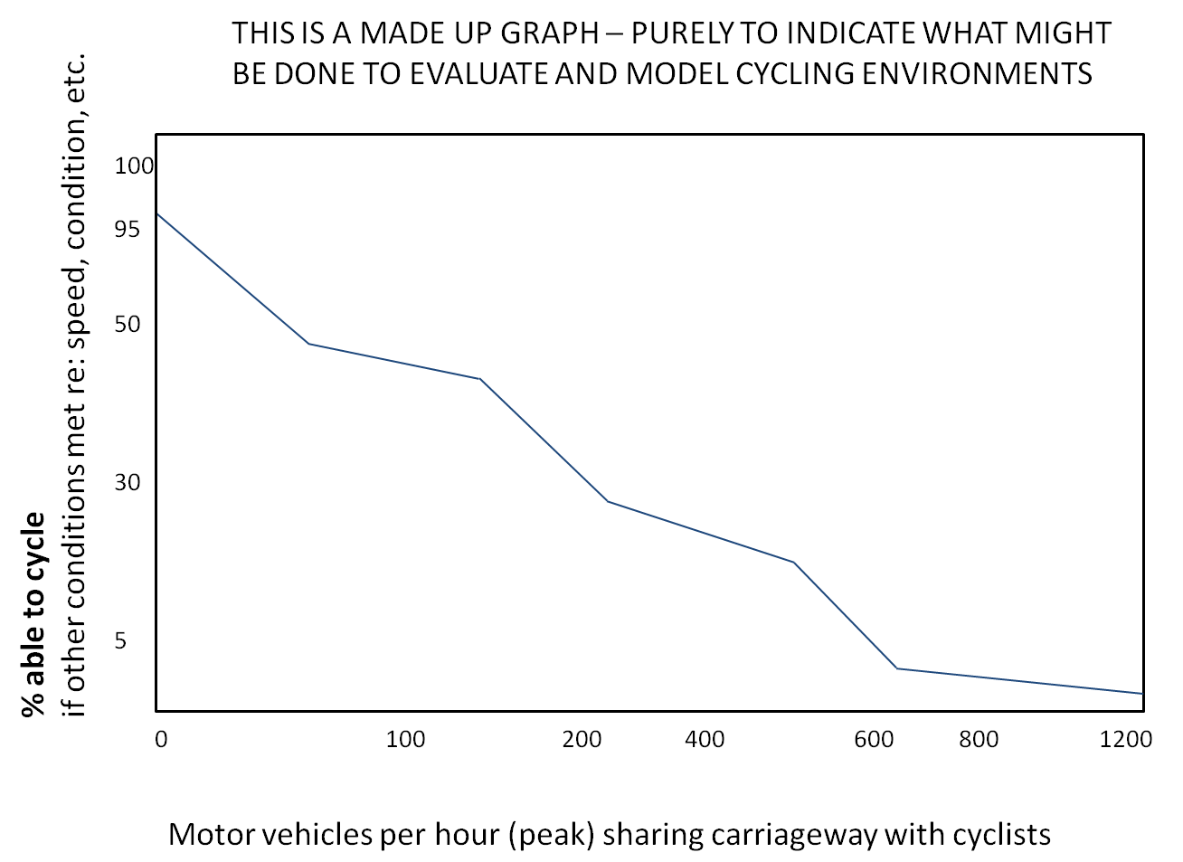
These kinds of parameters (for motor vehicle volume and other determinants of cycle-ability, such as motor vehicle speed) could be plugged into a network model of current trips, providing an estimate of the proportion of trips that are suitable for mass cycling, and allowing us to see which parts of a city suffer most from under-provision. (It might not be where we’d intuitively think). Depending on policy priorities, this could be used to prioritise improving school routes, for example, given that Cycle Infrastructure Design (LTN 2/08) says that children travelling to school will often need routes entirely separate from motor traffic. It could improve decision-making – perhaps there is a high-quality route that can be easily provided, but is it where people want to go now and will want to go in the future? Would it be better to focus on somewhere that might be more politically difficult, but which might yield much greater benefits? (and would the numbers help with that political difficulty?)
Importantly (in my view) we still don’t identify and prioritise a core network for cycling in different areas (a ‘cycle priority network’?), based on evidence about where most people want to go. Cycling needs connectivity, and the ability to accurately predict cycling, and intervene to increase it, will depend on looking broadly across the network, examining who goes where and why (and, looking at predicted land use changes, what journey patterns will be like in the future). We could then establish through research and modelling what level of service is needed to make this network cycle-able by the great majority of potential cyclists (85%? 95%?), and implement these measures as a priority. Bridleways could be an important part of the network in rural areas: they are legally cycle-able but, like main roads, often not so in practice, particularly for year-round utility cycling. (I hope this is the kind of thing that the Welsh Active Travel Bill will start doing). Having a clear definition and clear evidence of what mass cycling requires in practice (and the benefits that will stem from this) could help challenge the tendency in low-cycling countries to downgrade cycling provision when faced with competing priorities.
In conclusion: I would like to see both network models and small-scale traffic flow models incorporating a better understanding of how cyclists behave, and what level of changes are needed for more people to be able to cycle. Choices about cycling (and not-cycling) need to be understood as different from pedestrian or driver behaviour and preferences – this doesn’t mean they’re irrational, just that we haven’t yet successfully modelled them. In addressing this, it may be useful to experiment with different types of modelling; for example, system dynamics models can be used to explore the broader impacts of policy change (rather than looking at changes to specific parts of networks), while agent-based modelling can be used to explore social influence and social learning, both important for cycling as a minority mode that we seek to grow. Both intervening in traditional modelling, and exploring new perspectives are necessary, I think. Comments (either as responses to this post or emails) very welcome…
Good stuff! This crossed my mind: your basis seems the assumption that traffic modelling is required, useful and helps decision-making. I stipulate that traffic modelling in many cases may not be needed and is overused. Any thoughts?
One of my most commonly-asked questions is not where to end up, but where to begin? Let us consider, then, those features of an amenable cycling environment which are absolutely essential.
A couple of years after I first had the idea for compass colours, I decided to get serious about this, and I gave up my place at university and began working as a mini-cab driver. On one occasion, I was heading towards Kingston Bridge on the A310 Kingston Road / Upper Teddington Road (Street View), when I saw a female cyclist up ahead. The LCN route went via Broom Road / Lower Teddington Road, and I was curious to know why she wasn’t using it. So I overtook her, stopped at a reasonable distance ahead of her, and flagged her down. She told me that the back street route was not as direct as the main road route, and that it was basically as simple as that.
From this I concluded that routes need to be meaningful (in the sense that they need to go to the places that people most want to go) and direct before they are anything else. I say this because if a route is not meaningful and direct now, it is never likely to be meaningful and direct; but if a route is not safe now, well, this can be changed.
If a route can be identified which is pleasant, as well as being meaningful and direct, so much the better. Naturally, everyone would prefer to ride through a park or alongside a canal rather than beside a busy road, but more than this, according to a publication entitled Cycling in the Netherlands, “Cyclists often prefer a quiet residential street to an autonomous bicycle path alongside busy traffic arteries.”
Identifying routes that are meaningful and direct and pleasant is something that can only be done during the ‘planning’ phase, and creating routes which are safe and smooth and seamless is something that can only be done during the ‘development’ phase; so there ought to be no debate about what comes first.
So, meaningful and direct first, and pleasant wherever possible (but never to the detriment of the first two-listed factors).
Moving on, I think you’re right to say that cycling needs connectivity, which means to say of course that cycling needs a network (a network, by its very definition, is joined up). According to the European Cycling Federation, it is “a basic precondition” of mass cycling that the routes on such a network should be comprehensive (or dense) and city-wide.
What else? According to a European Parliament publication entitled Promotion of Cycling [pdf], “Mobility may be regarded as the ability to travel, although its meaning could be much broader, since mobility encompasses not only the activity of travel, but also, more importantly, the possibility for the traveller to decide when and where to travel, by being aware [of], and making use of, an information set for optimising the journey.”
Thus, the development of quality infrastructure is only part of the picture. Put another way, if quality infrastructure is to be built, then people need to be aware of it in order for it to be useful to them.
The importance of this was brought home to me following a blog by aseasyasriding about Royal College Street, Could this be the best cycling scheme in the UK? One of the commentators, who had “been cycling up Camden High Street […] every couple of weeks for the best part of a decade”, was not even aware of the facility on Royal College Street, this despite the fact that he lives in Kentish Town and needs to get down to Kingsway (map.
Cyclists in the City recently featured a comment from Clare H, who lives in Fulham and works in Holborn. She said that, to get to work, she goes “along Chelsea Embankment (on the shared-use pavement), then on CS8 to Parliament Sq (get off and walk), then along Victoria Embankment (hoping for the best along there), turning left before Temple, up Arundel St (then get off and walk), then up Chancery Lane, winding around High Holborn and ending up at Red Lion St. Phew!” I was able to point her to a different route (G1a – R1a) which took her through Hyde Park and which avoided the difficult junctions (here). Whilst it is far from perfect, there are actually some quite good bits.
She also said: “I’d like to be able to encourage my friends to choose to cycle too, but they look at the roads and decide it’s too scary. I know they would take it up if there were safe traffic-free routes.” How true! But where to begin!?
Charlie Lloyd (Campaigns Officer, LCC) has previously said: “Going Dutch is not really about segregation. It is about planning for people to have easy, safe access to wherever they want to go.” The first part is somewhat debatable. (aseasyasriding has recently said: “The guiding principle of Dutch design – and why they are so successful at maintaining such a high level of cycling – is indeed separation of bicycles and motor traffic.”) But the second part seems to me to be spot-on.
However, having planned “for people to have easy, safe access to wherever they want to go”, there needs also to be “an information set” which people are aware of, and can make use of, in order to optimise their journey.
The foregoing I regard as the basics, the essentials. The first step, perhaps, is to think in terms of a network. As David Hembrow has said: “I have argued for many years that there needs to be a more strategic view amongst cycling campaigners. […] Fighting little battles over minor issues repeatedly does not make progress.”
In sum, I worry that we are drowning in minutiae: we haven’t got an eye on the bigger picture, and nor have we put the basics in place.
This is from Crossrider (aka Cycalogical):
“The crucial point [is] that cycle infrastructure is not about spot treatments […] and isolated interventions: we need to start by defining the desired end-state.”
Very interesting ideas. Two thoughts that you don’t seem to have considered. From the perspective of the modeller:
1) Getting baseline data to model cycling is just ‘too hard’. Traffic is easy, as it has to stick to roads. Get some junction counts, ATC data and a bit of OD and you’re away. Cycles can use roads, then take a shortcut and ‘vanish’ from the normal network.
2) Modellers love ‘neutrality’. Most traffic models assume a neutral month. Typically these are September-November and April-June. Don’t try telling me that cycling patterns are the same in November as in June.
Nice post, and I like the idea of the ‘cycle-able’ network. As Richard points out, this is unlikely to fit well with a general multi-modal model. But I could see it working as a research tool to understand how many people are likely to cycle, and might lead to some interesting conclusions.
Pingback: Governing the transport transition | NewCycling